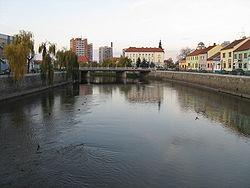
Thaya
You can help expand this article with text translated from the corresponding article in Czech. (March 2024) Click [show] for important translation instructions.
|
| Thaya Dyje | |
|---|---|
 The Thaya in Břeclav | |
| Location | |
| Countries | |
| Regions/ States | |
| Physical characteristics | |
| Source | German Thaya |
| • location | Mähring, Upper Palatine Forest, Germany |
| • elevation | 658 m (2,159 ft) |
| Mouth | |
• location | Morava |
• coordinates | 48°37′0″N 16°56′26″E / 48.61667°N 16.94056°E |
• elevation | 148 m (486 ft) |
| Length | 311 km (193 mi) |
| Basin size | 12,772 km2 (4,931 sq mi) |
| Discharge | |
| • average | 43.9 m3/s (1,550 cu ft/s) near the estuary |
| Basin features | |
| Progression | Morava→ Danube→ Black Sea |
 | |
The Thaya (Czech: Dyje, [ˈdɪjɛ]) is a river in the Czech Republic and Austria, a right tributary of the Morava River. It flows through the South Moravian Region in the Czech Republic and through Lower Austria in Austria. It is formed by the confluence of the German Thaya and Moravian Thaya rivers. Together with the German Thaya, which is its main source, the Thaya is 311 km (193 mi) long. Without the German Thaya, it is 212.8 km (132.2 mi) long. In the Czech Republic, the Thaya with the Moravian Thaya is 235 km (146 mi) long, making it the 6th longest river in the country.
Its drainage basin is 12,772 km2 (4,931 sq mi).[1]
The confluence of Thaya and Morava is the southernmost and the lowest point of Moravia.
Its name means "the inert". There is also a small village which bears the name Dyje, located near Znojmo.
Geography
[edit]In its upper reaches, the Thaya flows through deep gorges (Podyjí), along which it passes many castles and chateaus. In Moravia, it has been dammed in several locations.
Thaya gathers waters from the western half of Moravia and the adjacent part of Lower Austria. Its biggest tributaries are Svratka and Jihlava, flowing together into the middle one of the Nové Mlýny reservoirs.

Important cities and towns along the Thaya:
- Raabs an der Thaya
- Drosendorf-Zissersdorf
- Hardegg
- Laa an der Thaya
- Waidhofen an der Thaya
- Lednice
- Břeclav
- Vranov nad Dyji
- Znojmo
References
[edit]- ^ "Flächenverzeichnis der Flussgebiete: Donaugebiet von der Enns bis zur Leitha" (PDF). Beiträge zur Hydrografie Österreichs Heft 62. December 2014. p. 150.
External links
[edit]- River flow at Břeclav-Ladná station – Flood Warning and Forecasting Service of the Czech Hydrometeorological Institute
