La Vallee, Ontario
Appearance
(Redirected from Big Fork, Ontario)
La Vallee, Ontario | |
|---|---|
| Township of La Vallee | |
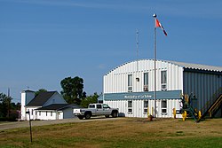
 Municipal office in Devlin | |
| Coordinates: 48°37′N 93°39′W / 48.617°N 93.650°W | |
| Country | Canada |
| Province | Ontario |
| District | Rainy River |
| Government | |
| • Reeve | Lucille MacDonald |
| • Federal riding | Thunder Bay—Rainy River |
| • Prov. riding | Kenora—Rainy River |
| Area | |
| • Land | 237.84 km2 (91.83 sq mi) |
| Population (2016)[1] | |
• Total | 938 |
| • Density | 3.9/km2 (10/sq mi) |
| Time zone | UTC-6 (CST) |
| • Summer (DST) | UTC-5 (CDT) |
| Postal Code | P0W 1C0 |
| Area code | 807 |
| Website | www.lavallee.ca |
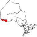
La Vallee is a township in the Canadian province of Ontario, located within the Rainy River District. It stretches for 6 miles (9.7 km) along the north side of the Rainy River, with a depth of 15 miles (24 km), and consists of the geographic townships of Devlin, Burriss and Woodyatt. The township had a population of 938 in the Canada 2016 Census, down 5.1% from 2011.
Demographics
[edit]In the 2021 Census of Population conducted by Statistics Canada, La Vallee had a population of 788 living in 319 of its 379 total private dwellings, a change of -16% from its 2016 population of 938. With a land area of 237.12 km2 (91.55 sq mi), it had a population density of 3.3/km2 (8.6/sq mi) in 2021.[2]
Canada census – La Vallee community profile
| 2021 | 2016 | 2011 | |
|---|---|---|---|
| Population | 788 (-16.0% from 2016) | 938 (-5.1% from 2011) | 988 (-7.4% from 2006) |
| Land area | 237.12 km2 (91.55 sq mi) | 237.84 km2 (91.83 sq mi) | 237.50 km2 (91.70 sq mi) |
| Population density | 3.3/km2 (8.5/sq mi) | 3.9/km2 (10/sq mi) | 4.2/km2 (11/sq mi) |
| Median age | 44.8 (M: 44.0, F: 45.2) | 43.6 (M: 43.7, F: 43.1) | 40.9 (M: 40.4, F: 41.4) |
| Private dwellings | 379 (total) 319 (occupied) | 395 (total) | 383 (total) |
| Median household income | $99,000 | $82,176 |
| Year | Pop. | ±% |
|---|---|---|
| 1991 | 1,081 | — |
| 1996 | 1,130 | +4.5% |
| 2001 | 1,073 | −5.0% |
| 2006 | 1,067 | −0.6% |
| 2011 | 988 | −7.4% |
| 2016 | 938 | −5.1% |
| [6][1] | ||
See also
[edit]References
[edit]- ^ a b c "Census Profile, 2016 Census: La Vallee, Township". Statistics Canada. Retrieved July 2, 2019.
- ^ "Population and dwelling counts: Canada, provinces and territories, census divisions and census subdivisions (municipalities), Ontario". Statistics Canada. February 9, 2022. Retrieved April 2, 2022.
- ^ "2021 Community Profiles". 2021 Canadian census. Statistics Canada. February 4, 2022. Retrieved 2023-10-19.
- ^ "2016 Community Profiles". 2016 Canadian census. Statistics Canada. August 12, 2021. Retrieved 2019-07-02.
- ^ "2011 Community Profiles". 2011 Canadian census. Statistics Canada. March 21, 2019. Retrieved 2012-03-30.
- ^ Statistics Canada: 2001, 2006, 2011 census
External links
[edit]


