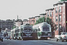
Back of the Hill station
Back of the Hill | |||||||||||
|---|---|---|---|---|---|---|---|---|---|---|---|
 An inbound train at Back of the Hill station in 2011 | |||||||||||
| General information | |||||||||||
| Location | South Huntington Avenue at Back of the Hill Boston, Massachusetts | ||||||||||
| Coordinates | 42°19′45.79″N 71°6′39.46″W / 42.3293861°N 71.1109611°W | ||||||||||
| Platforms | None (passengers wait on sidewalk) | ||||||||||
| Tracks | 2 | ||||||||||
| Connections | |||||||||||
| Construction | |||||||||||
| Accessible | No | ||||||||||
| History | |||||||||||
| Opened | c. 1982 | ||||||||||
| Passengers | |||||||||||
| 2011 | 35 (weekday average)[1] | ||||||||||
| Services | |||||||||||
| |||||||||||
| |||||||||||
Back of the Hill station is a surface stop on the light rail MBTA Green Line E branch, located in the Mission Hill neighborhood of Boston, Massachusetts. It is named after, and primarily serves, the adjacent Back of the Hill apartment complex, a Section 8 development for elderly and disabled residents. Back of the Hill is located on the street running section of the E branch on South Huntington Avenue. The station has no platforms; passengers wait in bus shelters (shared with route 39 buses) on the sidewalks and cross a traffic lane to reach Green Line trains.[2]
History
[edit]
The Boston Elevated Railway opened streetcar tracks on the newly-laid-out South Huntington Avenue between Centre Street and Huntington Avenue on May 11, 1903. The company began Jamaica Plain–Park Street service via South, Centre, South Huntington, and Huntington as a branch of existing Boston–Brookline service on Huntington Avenue.[3][4]: 61 All Huntington Avenue service (except for Northeastern University and Brigham Circle short turns) operated on South Huntington after September 10, 1938.[5] The line became part of the Metropolitan Transit Authority in 1947, and part of the Massachusetts Bay Transportation Authority (MBTA) in 1967; it was designated as the E Branch of the MBTA Green Line in 1967.[6]
By the 1970s, E Branch trains stopped at Riverway and Heath Street, with no stop between them.[7] The Back of the Hill apartment complex, located just north of Heath Street, was built in 1980 and opened in 1981.[8][9][10] The E Branch was closed for track work from June 21, 1980, to June 26, 1982; trains began stopping at Back of the Hill then or after.[6]
Back of the Hill is the least-used stop on the MBTA subway system, averaging only 35 riders per day by a 2011 count. It was one of only four stops to average fewer than 100 riders per day.[1][note 1] In 2021, the MBTA indicated plans to modify the Heath Street–Brigham Circle section of the E branch with accessible platforms to replace the existing non-accessible stopping locations.[11] The new platforms are planned to be long enough to accommodate two 110-foot (34 m) Type 10 vehicles. Design work began in July 2023 and is expected to reach 15% completion in July 2024.[12][13]
References
[edit]- ^ a b "Ridership and Service Statistics" (PDF) (14th ed.). Massachusetts Bay Transportation Authority. 2014.
- ^ "Back of the Hill Station Neighborhood Map" (PDF). Massachusetts Bay Transportation Authority. July 2012.
- ^ "New Route Open". Boston Globe. May 11, 1903. p. 11 – via Newspapers.com.

- ^ Clarke, Bradley H.; Cummings, O.R. (1997). Tremont Street Subway: A Century of Public Service. Boston Street Railway Association. ISBN 0938315048.
- ^ Barber, Richard (March–April 1984). "Fifty Years Ago... The Last Days of Cypress Street Carhouse". Rollsign. Vol. 21, no. 3/4. Boston Street Railway Association. pp. 3–7.
- ^ a b Belcher, Jonathan. "Changes to Transit Service in the MBTA district" (PDF). Boston Street Railway Association.
- ^ Thomas K. Dyer Inc. (1972). "Green Line Station Mileage from Lechmere". Plan for Acquisition and Use of Railroad Rights-of-Way. Massachusetts Bay Transportation Authority.
- ^ Seidman, Karl; Lee, Tunney; Selinger, Elise (April 2016). From Urban Renewal to Affordable Housing Production System: Boston Mayors and the Evolution of Community Development Corporations in Boston (PDF) (Report). Community Innovators Lab, MIT Department of Urban Studies and Planning. p. 39.
- ^ "Back of the Hill Apartments to Remain Affordable for Low-Income Seniors and Disabled Residents" (PDF) (Press release). Massachusetts Housing Finance Agency. November 20, 2006.
- ^ "Mission Hill battle is finally won". Boston Globe. February 15, 1981. p. 35 – via Newspapers.com.

- ^ Peña, Angel (June 21, 2021). "Green Line Transformation (GLT) Update" (PDF). Massachusetts Bay Transportation Authority. p. 7.
- ^ "System-Wide Accessibility Initiatives—November 2023" (PDF). Massachusetts Bay Transportation Authority Department of System-Wide Accessibility. November 27, 2023. p. 5.
- ^ "Accessibility Initiatives—June 2024" (PDF). Massachusetts Bay Transportation Authority. June 25, 2024. p. 5.
- ^ The others, as of 2014, are Valley Road (44 riders/day), Capen Street (58 riders/day), and Cedar Grove (91 riders/day), all on the Ashmont–Mattapan High Speed Line.
External links
[edit]![]() Media related to Back of the Hill station at Wikimedia Commons
Media related to Back of the Hill station at Wikimedia Commons

