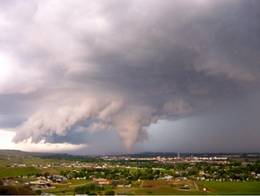
2010 Billings tornado
| EF2 tornado | |
|---|---|
 The tornado as it was moving through Billings, Montana | |
| Formed | June 20, 2010 3:24 p.m. MST (UTC−07:00) |
| Dissipated | June 20, 2010 3:36 p.m. MST (UTC−07:00) |
| Highest winds |
|
| Max. rating1 | EF2 tornado |
| Duration of tornado outbreak2 | 12 minutes |
| Fatalities | 1 injury |
| Damage | $30 million (2010 USD) |
| Areas affected | Yellowstone County, Montana (part of a larger outbreak) |
Part of the tornado outbreaks of 2010 1Most severe tornado damage; see Enhanced Fujita scale 2Time from first tornado to last tornado | |
A destructive EF2 tornado hit Billings, Montana on Sunday, June 20, 2010 (Father's Day). Known as the 2010 Father's Day tornado, the strong tornado was on the ground for about 12 minutes and took the roof off the First Interstate Arena at MetraPark (then named the Rimrock Auto Arena), a 10,000 seat arena, and heavily damaged numerous businesses.[1] The storm was accompanied by high winds and a major hail storm that caused severe damage and flash flooding in the Heights section of the city. It was the first time since 1958 that a significant tornado struck the Downtown Billings area.[2]
Synopsis and tornado event
[edit]An unsettled pattern continued across a large part of the US, with widespread isolated tornadoes across various parts of the Plains states. The most notable tornado touched down in Billings, Montana at the MetraPark trade facility. Damage was significant, including a large section of the roof being removed at the Rimrock Auto Arena at MetraPark.
The Storm Prediction Center in Norman, Oklahoma had issued a severe thunderstorm watch for south-central Montana, including Yellowstone County, at 1:55 pm CDT on June 20, in anticipation of active severe weather throughout the region.[3] Strong southwesterly flow aloft combined with a moderately unstable air mass created conditions favorable for producing severe thunderstorms, and potentially tornadoes.[4]
A supercell thunderstorm moved through the Billings area in the late afternoon. At approximately 4:24 pm MDT, a tornado touched down near the intersection of Lake Elmo drive and Main Street. It damaged several buildings, including tearing roofs off of multiple structures. It also downed several power poles and billboards, and uprooted multiple trees. The tornado moved south, where it struck the Rimrock Auto Arena at MetraPark, tearing off a large portion of the roof and doing nearly $27 million worth of damage to the arena.[5] The tornado lofted debris and deposited it as far as one mile from the damage path. After approximately 12 minutes on the ground, the tornado dissipated over the arena. The storm then moved northeast, producing numerous funnel clouds, but no further touchdowns.[6]
Aftermath
[edit]The damage survey revealed damage from the tornado consistent with wind speeds of 120–135 mph (193–217 km/h), garnering a rating of EF2. It was the strongest tornado to strike the Billings area in over 50 years.[7] Despite the major damage in the urban area, only some minor injuries were reported.[1]
See also
[edit]References
[edit]- ^ a b Pickett, Mary. "Tornado destroys Metra, several Heights businesses". The Billings Gazette. Retrieved 29 August 2012.
- ^ "Montana Tornado Rips Roof off Sports Arena". CBS News. Retrieved 29 August 2012.
- ^ Center, Storm Prediction. "Storm Prediction Center Tornado/Severe Thunderstorm Watch Page". www.spc.noaa.gov. Retrieved 24 November 2020.
- ^ "Storm Prediction Center Jun 20, 2010 1630 UTC Day 1 Convective Outlook". www.spc.noaa.gov. Retrieved 24 November 2020.
- ^ Hagengruber, Matt. "10 months later, a new arena ready to shine". The Billings Gazette. Retrieved 26 July 2018.
- ^ "Billings Tornado of June 20, 2010 Overview" (PDF). NOAA. Retrieved 26 July 2018.
- ^ "Tornado tears through Montana city, ripping roof off a sports arena". Fox News. Associated Press. Retrieved 26 July 2018.
